


The Life & Times of Jesus of Nazareth: Christian History Map - Getting Physical


Sideways? Like most of the ancient Near East, first-century Jews oriented themselves not by magnetic north, but by the sun's rising in the east. Thus, east (literally "in front" in Hebrew) would have been at the top of their maps. Still, this map would have made little sense because they also perceived the world as a flat disk or circle upon primeval waters or as a garment stretching across the void. Heaven and earth were thought to be sealed together at the rim of the horizon to prevent the influx of cosmic waters. Heaven rested on the earth, which was in turn set on pillars or foundations.
Interstate interchange. (A) Damascus was the intersection of Palestine's two major roads. The Great Trunk Road followed the mountain ranges to the Sea of Galilee (which it encircled), through Capernaum on the northwestern shore, then continued about five miles east of the Mediterranean sea through Gaza on its way to Memphis, Egypt. The King's Highway roughly followed the mountain range on the eastern side of the Jordan, ending at the Gulf of Aqaba.
Here there be dragons. (B) To the Jews and neighboring cultures, the sea was a dangerous and scary place. Not only was its power second only to God's (e.g. Jonah 2:5-6, Ps. 93:3-4), but it was thought to hold sea monsters—thus the hope of a "new earth" that has "no more sea," (Rev. 21:1).
Refrigerator. (C) The tallest mountain in the area, 9,232-foot Mount Hermon, is covered with snow most of the year. From biblical times until recently, the snow was carried to nearby villages in its foothills to cool foods and drinks. Though now on the Syria-Lebanon border, first-century Jews would have considered it part of their rightful land, as it represented the northwestern limit of the Israelite conquest under Moses and Joshua.
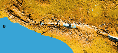
Skirting the Hula. (D) You'll find a lake here on Bible maps but not today. The Lake Hula Valley was once a desolate swamp avoided by humans and populated by water buffalo, wild boar, migratory birds, and mosquitoes. Fishing in the malarial lake, a nursery for papyrus and water lilies, was practically nonexistent. In 1951 the lake and swamps were almost completely drained to create farmland.
God's delight. (E) "The Lord has created seven seas," said the early rabbis, "but the sea of Gennesaret (Galilee) is his delight." Unlike the Dead Sea, it had clear, sandy beaches, countless fish, and affluent residents along its shores. The lake fills the crater of an extinct volcano, so it is surrounded by black basaltic rock.
Landlubbers. (F) Palestine's Mediterranean coastline is remarkably straight, with no natural harbors, and from the eleventh century b.c., the Philistines controlled it. (Hence the land was named Palestine, land of the Philistines.) These two facts explain the Jews' lack of maritime activity.
Out of Africa. (G) Most of Israel's geographical features were created by its location on the Afro-Arabian fault line, which stretches from Turkey to Mozambique—more than one-sixth of the earth's circumference. The Great Rift Valley that is home to Lakes Victoria and Nyasa reaches its deepest point, 2,570 feet below sea level, by the Dead Sea. Between 1900 and 1980 over 50 earthquakes occurred along the Dead Sea Rift.
Greater salt lake. (H) Averaging 1,312 feet below sea level, the Dead Sea is the lowest point on earth, (during Jesus' day it was another 115 feet lower). The 53-mile-long lake is also the world's saltiest body of water: between 26 and 35 percent salt. By contrast, Utah's Great Salt Lake is only 18 percent salt, and the ocean is 3.5 percent. But the area was a hot commodity for its bitumen (hardened petroleum), used mainly for caulking ships and embalming.
Vulnerable navel. (I) Jerusalem was horribly situated. It had only one reliable spring (Shiloah), and during droughts water had to be carried long distances to supply city residents. Its only raw material was stone. And since it was surrounded by higher mountains, it was not a strategic defensive location. Still, Jerusalem was considered the omphalos (the earth's navel), from which order was established and diffused to "those who dwell at the earth's farthest bounds."
Badlands. (J) After his baptism in the Jordan River just north of the Dead Sea, Jesus wandered in the barren Wilderness of Judea. Only a few miles north of Jericho, it is as barren and uninhabited as the badlands of North Dakota. The practice of baptism and seclusion in the Judean wilderness was common among the Essenes, who had a hideaway here.
Copyright © 1998 by the author or Christianity Today/Christian History magazine.
Click here for reprint information on Christian History.

Support Our Work
Subscribe to CT for less than $4.25/month


